Just when you thought Google has done it all with their Google Maps program, especially going out into space, they continue to show that there are no limits. With an announcement this week, Google Maps is now going underwater to show users in depth imagery of coastal reefs off of Australia, Hawaii and elsewhere. This came in collaboration with The Catlin Seaview Survey, an organization that observes and aims to protect the coral reefs of the world.

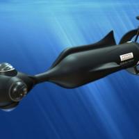
Google has utilized a special underwater camera called the Seaview SVII, which allows panoramic underwater photos to be taken. At a slow speed of just two miles an hour, the SVII takes a photo every three seconds, and then the series of photos are stitched.
The new underwater feature is part of the Google’s Streetview collection efforts, which has been in action for the past couple of years. Those who use Streetview might have a preview of the stitched photos; some are better than others, but the promise in the underwater photos are looking strong.
Fish, sea turtles, and all types other sea creatures are visible. It’s surprising the divers who took these photos got as close as they did to some of the animals. The preview video shows the divers and the SVII camera, and the device is pretty massive. However, it didn’t really seem to bother anyone.
While the photos will provide a heavy source of entertainment for those who are interested in using them, they can also certainly provide scientific and educational value as well. Marine biologists should be more than excited about this move, since they will be granted access to study visual fields of areas that they have not been to before. Though there is no applicability just yet, it’s reasonable to see that the underwater imagery will be able to get used in the classroom as well, providing students with something they may have never seen before.
Based on the preview video that has been circulating on the Internet, the way to access these photos basically works like Streetview. As long as the location has been photographed, one can start at the beach and go scroll right into the water. There the panoramas will be shown. The imagery is admittedly pretty incredible, and is certainly a huge step for Google and their efforts to make what is arguably the most comprehensive and detailed map of Earth that has ever been done.
The Catlin Seaview Survey’s role in this effort is actually pretty large. The divers who were responsible for taking the photos are members of the survey. Google may have have a lot of resources on hand, but I don’t think they have any divers available any way.
Many might have thought that after Google had done everything from map out the polar caps – and even the observable view of outer space – that might have been enough. But once again, they show that they are far from finished with the additions of Google Earth and Maps. From here, there’s no telling where they are going next.